The Napoleonic Wars began in 1803 and lasted until Napoleon’s defeat at Waterloo in 1815. The Geography and Map Division holds numerous maps of the battle. I am sharing images of a few of my favorites. I would like to begin with a brief summary of Napoleon’s final battle and the events that led to it.
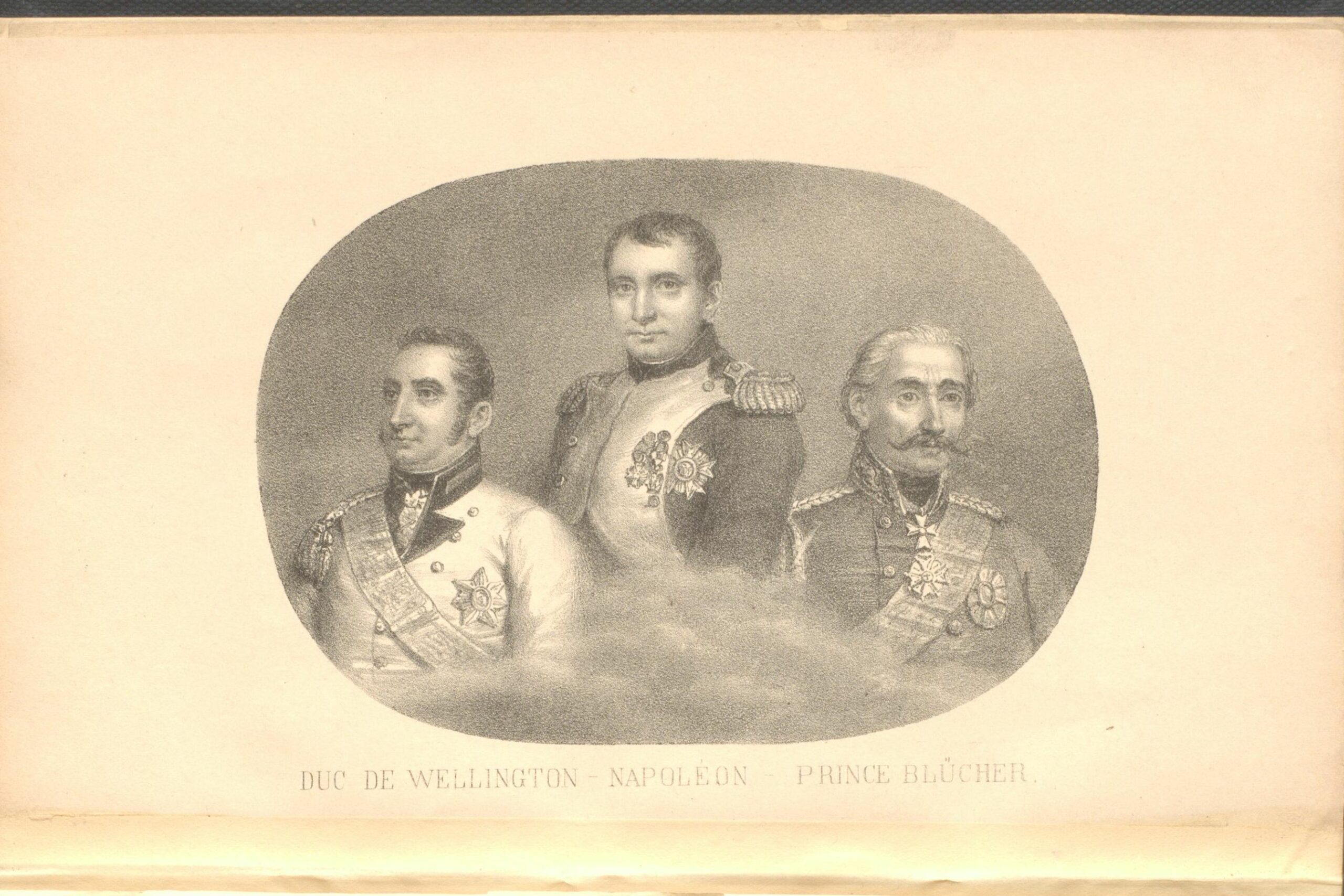
Pictured above are the commanders of the Battle of Waterloo: The Duke of Wellington, Napoleon Bonaparte, and Field Marshal Blücher. The Duke of Wellington’s Anglo-allied army included soldiers from the United Kingdom of Great Britain and Ireland, the United Kingdom of the Netherlands, and the German states of Hanover, Brunswick and Nassau. Marshal Blücher’s army consisted of soldiers from the Kingdom of Prussia.
In 1804 Napoleon Bonaparte, a military and political genius, became the Emperor of France. In October 1813, Napoleon’s Grande Armée was defeated by a coalition of armies at the Battle of Leipzig. After his defeat he was forced to abdicate the throne. On May 30, 1814, Napoleon was exiled to the island of Elba. Ten months later he escaped from Elba and returned to the throne, with the support of the French people. European countries began to mobilize with the goal of ending his rule. The British led Anglo-allied army and the Prussian army were both stationed in Belgium. Napoleon decided to attack the allied armies separately before they joined forces to invade France. On June 16, 1815, Napoleon’s forces attacked Marshal Blücher’s Prussian army at Ligny. In retaliation, the Duke of Wellington pointed to a map of Belgium and stated that he would stop Napoleon near Waterloo. The Battle of Waterloo began on Sunday, June 18, 1815. The Anglo-allied army fortified a farmhouse named Hougoumont. The farmhouse was one of the first points of attack. The French soldiers tried to enter the courtyard by storming through the gate. Wellington’s soldiers stopped them by forcing the gate shut as they entered it. On the battlefield, Wellington had wisely placed some of his troops behind a ridge which provided partial cover; however, as the battle progressed his soldiers suffered heavy casualties. Despite the dire circumstances, the situation was about to change. Marshal Blücher’s army emerged from the woods and broke through Napoleon’s right flank. Napoleon’s soldiers were forced to retreat, which resulted in a victory for the allied armies.
Featured below is a manuscript map titled The Battle of Waterloo Taken on the Spot after the Action of the 18th June 1815, Presented and Dedicated to H.R.H. the Duke of York, by Liet. Tyler 2nd. G.B. At the bottom of the map someone penciled the following line from a poem titled The Battle of Waterloo:
“Their country’s tears shall dew the grave where valour sleeps; and o’er the brave proud freedom shall her banner wave, to consecrate their victory”.

The Duke of Wellington and Marshal Blücher met near an inn named La Belle Alliance after the battle. Blücher wanted to name the battle La Belle Alliance, while Wellington preferred the name The Battle of Waterloo. Below is an image of a German map titled Plan der glorreichen Schlacht bei La Belle-Alliance am 18ten Juni 1815.

Featured below is a map that was made in 1816 by the cartographer and surveyor Willem Benjamin Craan. He interviewed veterans from both sides of the battle before the map was published in Belgium.

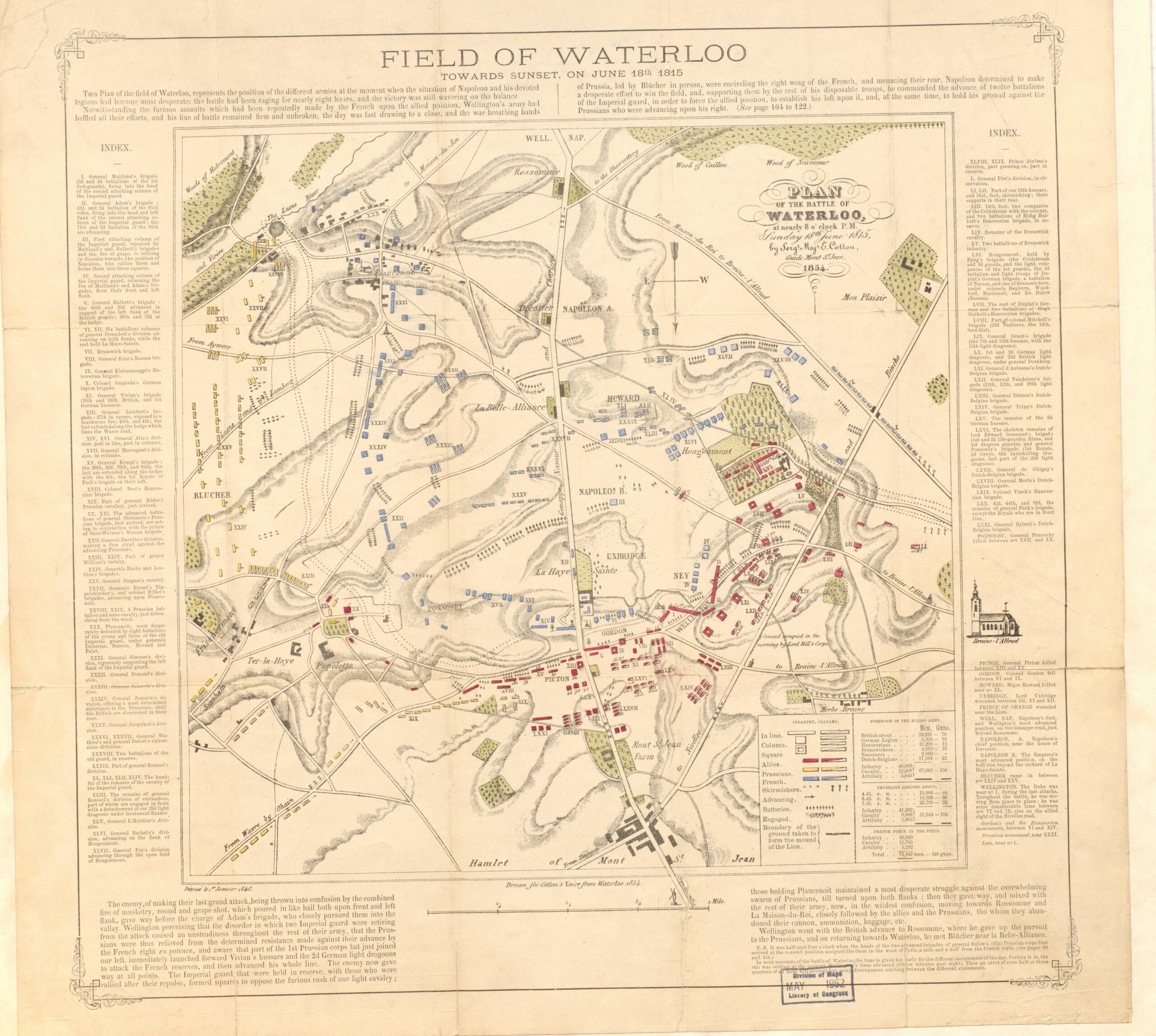
The map below was created by Sergeant Major Edward Cotton. Edward Cotton was a veteran of the Battle of Waterloo and author of the book A voice from Waterloo. He became a battlefield guide after his retirement from the British Army.

Napoleon was exiled to the British ruled island of Saint Helena after his defeat. He lived there until his death at the age of 51. Pictured above is a lithograph of Napoleon at Saint Helena.
Why did Napoleon lose the Battle of Waterloo? Many of Wellington’s soldiers were new recruits who had never fought in a battle before, in comparison to Napoleon’s veteran soldiers. Historians believe that Wellington’s use of the terrain placed his soldiers at an advantage. Many think that the French lost because of mistakes that were made by Napoleon’s commanding officers, Michel Ney and Emmanuel Grouchy. In my personal opinion, the tenacity of the allied armies was a major factor in their victory; they were determined to put an end to the Napoleonic Wars.
Comments (3)
Thank you for posting the Edward Cotton map. It is many years since I have seen it!
Thank you for your comment. It is a fine map, so very detailed.
Can someone please post a detailed map and timeline of battles in the Napoleonic War and how Napoleon moved through it color coded by war.